
Radius Mapping Services
L.A Mapping Service, Inc. is a full-service Radius Map provider in Southern California
Get your Radius Mapping
today!
High-Quality Radius Maps for Diverse Applications
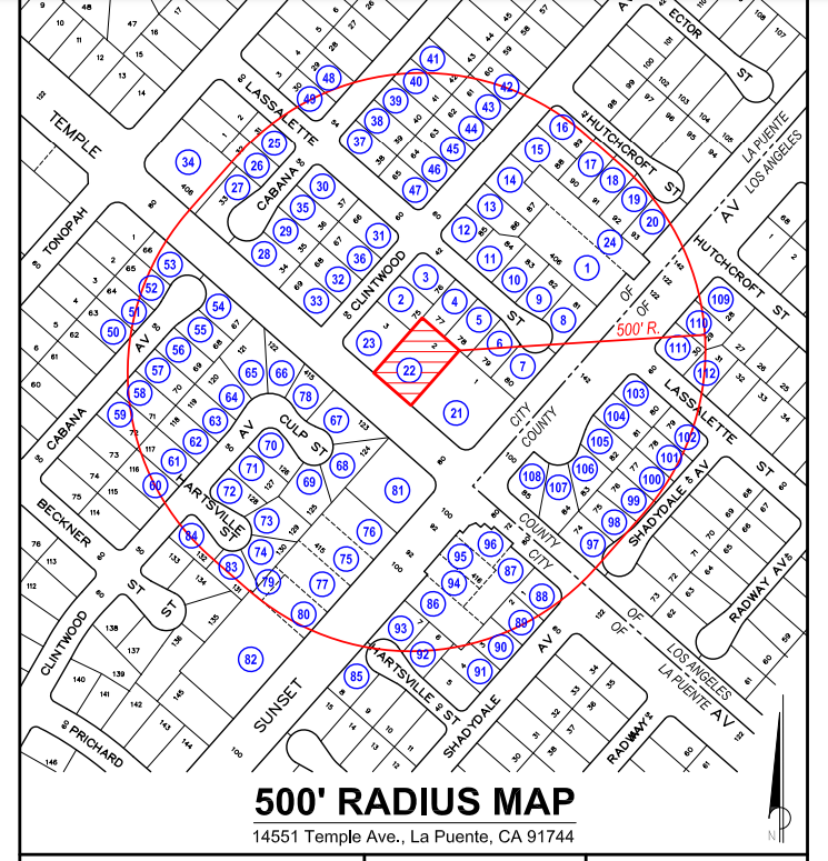
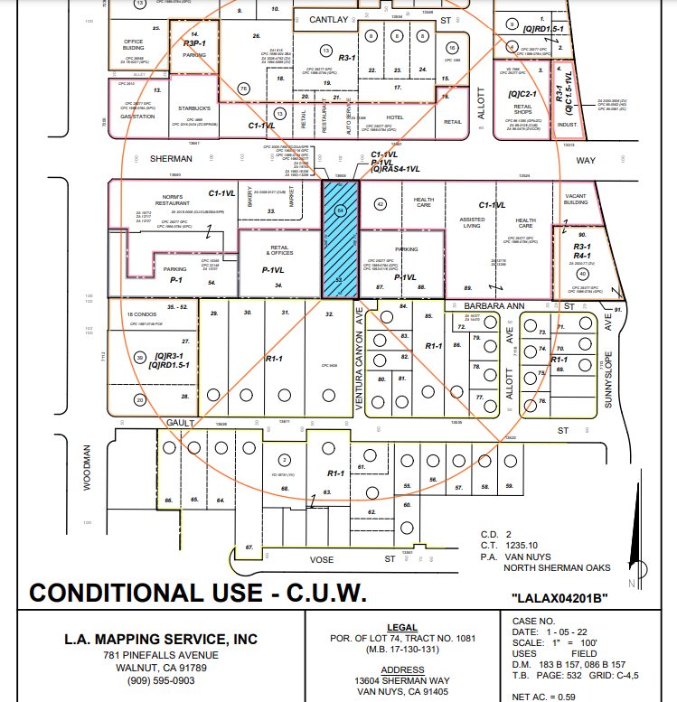
L.A. Mapping Service, Inc. offers High-Quality Radius Maps, a vital tool for a multitude of applications spanning from urban development to environmental analysis.
These maps are invaluable for a variety of stakeholders, including real estate developers who rely on them for site selection and land development, urban planners for city development projects, and governmental agencies for regulatory and planning purposes. Beyond Radius Maps, our portfolio includes Vicinity Maps and Land Use Maps, essential for comprehensive area planning and zoning considerations.
Our commitment to delivering user-friendly, accurate maps makes them not just tools for analysis but also instruments for strategic decision-making. Choose L.A. Mapping Service, Inc. for Radius Maps that blend precision with practicality, catering to a broad spectrum of professional mapping needs.
Advanced Radius and Custom Mapping Solutions
All of our radius maps are created to the highest quality and scale using GIS, AutoCAD, and various other types of mapping software.
We provide accurate maps of any size radius. (100 ft radius (100'), 300 ft radius (300'), 500 ft radius (500'), 1000 ft radius (1000'), etc.)
We prepare maps of all types, including:
- Radius Maps
- Assessor’s Parcel Maps
- Ownership Maps
- Land Use Maps
- Vicinity Maps
- Zoning Maps
- Location Maps
- Adjacent Owners Maps
- Photographic Survey Maps
- Aerial Photo Maps
- Blank Maps
- Assessor’s Parcel Maps
- Posted Signs
- California State Coastal Commission
- Haul Route
Ask about a free digital file with your Radius Map Package.


Welcome to LA Mapping Service
Our Services
Experience accurate and customized radius maps and ownership lists for your specific needs. Trust our expertise in delivering top-quality mapping services and most up-to-date county assessor’s data.
All of our Radius Maps are created in the highest quality and to scale using GIS, AutoCAD , etc.

We provide a Certified Affidavit guaranteeing the accuracy of each list.
We offer high quality printing, envelopes, postage and mailing services when needed.

Service Coverage
Providing mapping services for all Cities and Counties in California
We provide mapping services for all Cities in all Counties throughout the entire State of California.
List of Cities & Counties in California we provide services for:
CASE TYPES
You may need a radius map and notification package if you are filing an application for any of these cases.
- Conditional Use Permit (CUP)
- Minor Conditional Use Permit (MCUP)
- Wireless Telecommunications Permit (WTP)
- Temporary Use Permit
- Minor Use Permit Major Use Permit
- Zone Variance (ZV)
- Coastal Development Permit (CDP)
- Site Plan Review (SPR)
- Environmental Impact Report
- Conditional Use Permit (CUP)
- Minor Conditional Use Permit (MCUP)
- Wireless Telecommunications Permit (WTP)
- Temporary Use Permit
- Minor Use Permit Major Use Permit
- Zone Variance (ZV)
- Coastal Development Permit (CDP)
- Site Plan Review (SPR)
- Environmental Impact Report
- Conditional Use Permit (CUP)
- Minor Conditional Use Permit (MCUP)
- Wireless Telecommunications Permit (WTP)
- Temporary Use Permit
- Minor Use Permit Major Use Permit
- Zone Variance (ZV)
- Coastal Development Permit (CDP)
- Site Plan Review (SPR)
- Environmental Impact Report
Why is LA Mapping Service So Popular?
LA Mapping Service has provided high-quality radius maps to customers throughout California for years. When it comes to radius map services, you won't find a more reliable and accurate company than LA Mapping Service.
Contact our team today for all your radius map needs. Whether you're looking for a radius map, certified affidavits, or certified notary services, LA Mapping Service has got you covered.